
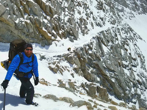
Photo courtesy of John Colver - Walkabout on the south side of Forester Pass, May 2017
PCT NOBOs are entering the Sierra! Some are trying to bypass but the ones going through are being rewarded with plenty of grandeur. Here's what those who have hiked through are reporting back.
1. There's a lot of snow! Over 90% of the trail is covered in snow.
2. Ice axe and crampons are HIGHLY recommended.
3. Get up early! Very early! The hikers coming through are walking by about 5am. It's very cold so the morning routine takes a little longer. Start your day with something hot to get you going.
4. You're done walking by around 1pm. The snow is too soft in most cases to continue on much later than that.
5. Take extra fuel. The higher elevation and the cold increase the time it takes to bring your water to a boil.
6. Plan on about 10-12 miles a day. You might do more some days but you might do less other days.
7. Be prepared for storms! Last week another 0.5-1 ft of snow covered the fresh footprints and dropped temperatures significantly during that time. Weather can change quickly so be prepared for anything when you head into the mountains.
8. Forester Pass now has a trail cut thanks to Ghost, Yukon Jack, and Walkabout. Thanks guys!! This was a long, tedious, and arduous task but it's done now.
9. Currently there are snow bridges over all the major creeks. These are not going to last very long. Temps are rising.
10. Navigating hasn't been too bad. Don't rely on your phone. It's too cold to keep them operating in the early hours in the morning. Take paper maps. If you can, take a GPS with the trail waypoints loaded.
Exit Points
1. Olancha Pass Trail (~Mile 720.6) is a good exit point if needed. It's snow-free up to here from the reports I've gotten. As you descend from the mountains you can see a Mobil Gas Mart along Hwy 395. You can walk cross-country to get there and hitch north to Lone Pine.
2. Trail Pass Trail (~Mile 745) no recent report. Still snowy but I know hikers have come out here.
3. Cottonwood Pass Trail (~Mile 750) is not blazed. It's steep and icy. Crampons and ice axe were an absolute must a week ago. The trail was difficult to follow in the deep snow.
4. Bullfrog Lake Trail & Kearsarge Pass Trail (~Mile 788 & 789) all snow down to Onion Valley. You can get cell service usually at the top of Kearsarge Pass but it can be very spotty when moving lower. The parking lot is still buried in snow but it's melting pretty fast. On the weekends you will likely see some hikers but with all the snow there may not be a lot of people to hitch down with. This is still a highly recommended exit point for resupply and everyone thus far that I've heard of going through the mountains has come out here.
Reminder
Sleep with your Sawyer filter! If they freeze it damages them and they will no longer filtering your water properly. There's no way to inspect the Sawyer for damage if this happens so it's best to seal it in a ziplock bag or dry sack and place it in your sleeping bag at night.
Stay safe out there and enjoy the beauty! It's abundant right now!
Mary & Charlie