
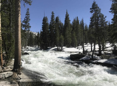
Bear Creek Raging - photo from The Bobby Blaine (www.instagram.com/thebobbyblaine)
Are the Sierra impassable? Technically no, BUT that's the word that most of your fellow hikers are using. These are not beginner hikers, these are seasoned veterans of the trail. It is "possible" to get across, but is it worth the risk?
I'll put it another way, one of the guys leading the way through the Sierra is off trail. Why? One of his good friends called to tell me he got swept downstream in a river; he lost EVERYTHING but his life, and he was lucky. He was freezing cold, in wet clothes, no food, no water, nobody around. He retreated 15 miles and luckily was able to flag down a snow plow. The hiker is now home. There is no more PCT for him this year. His gear is gone but he's grateful, so grateful he's not. This happened near Mile 1000 in the last couple of days.
I tell you all this because the danger in the Sierra right now is real! Evolution Creek is deep but "swimmable" if you have a group. Bear Creek and the North Fork of Mono Creek have been called impassable by multiple experienced hikers this week. You can hike out to the west towards Florence Lake exiting near Muir Trail Ranch (Mile 859) and returning to the PCT via VVR and the Goodale Trail (Mile 886). BUT then you will have the Tuolumne River and reports from there a week or so ago were already saying it was unsafe; I doubt that has improved.
So where now?
~ Hike to Lone Pine - No bear canister, spikes, or ice axe needed to get here. Public transit is available here. Stop by and ask me for the latest info up the trail if needed.
~ Lone Pine to Kearsarge Pass - the rivers are rising. Hitting some of the creeks in late day was "a mistake" a few hikers reported as was going over Forester Pass in the later afternoon/evening. Tyndall Creek took a hiker's pack late in the day, but he was able to recover it; crossing in the morning wasn't bad.
~ Donner Pass - lots of snow still. Be sure to have at least microspikes and carry your ice axe too. Snow bridges were in tact but these could be melting by now. 3-10 ft of snow.
~ Sierra City - carry a GPS. The trail is still not visible. The snowline is around 6000 ft. Much of the trail is still under snow. Ridgelines are still snowy and have a risk of sliding/falling. Carry ice axe and spikes.
~ Belden - hikers reported snow above 6000-ish ft. No trail and dangerous. The group had a couple of falls and decided it was a bit much and left for a side trip. They will return early July.
~ Chester/Quincy - many hikers are heading here since it's accessible via public transit. No reports on actual conditions here.
~ Lassen - lots of snow still around there.
~ Old Station & Burney Falls - many hikers heading to this area. There's patchy snow and potentially still 10+ miles especially in the Grizzly Peak area. The report a week ago was "it was sketchy" but doable. The additional warm weather this week has possibly improved conditions.
~ Castle Crags - snow free coming in. Very steep snowy traverses between here and Seiad Valley. Must have GPS, spikes, and ice axe.
~ Seiad Valley - Snowline is around 5500 ft and the trail is mostly under snow. GPS, ice axe, and crampons needed.
~ Ashland - A couple groups of hikers have started SOBO from here back to Kennedy Meadows/Lone Pine. Shortly after leaving Ashland at least one of the group's were back off trail reporting "too much snow". The other group pushed through but said it was really intense, many steep traverses; very little trail visible here and snow/traction gear is mandatory.
~ Washington - snowline is currently around 4000 ft with a thick base.
Rain is coming to NorCal and Oregon this weekend. Be prepared for falling temps, light snow, and definitely rain!
Everyone, please be super careful and hike with a buddy until the snow is gone and the water levels drop. As always, if you have questions, let me know. I'll do my very best to get you answers!
Mary & Charlie